 Republic of Nauru Google Maps and Facts
Welcome to the Google Maps of Nauru (NR) and the comprehensive location list for this country. World Route Planner, together with its detailed Nauru page, turns Google Maps Sightseeing into a meaningful experience! Our extensive destination gazetteer, coupled with Driving Directions to Nauru, allows you to explore Nauru through detailed satellite imagery and street views—fast, free, and easier than ever before.
Browse through the list of administrative regions in Nauru, navigate through these regions to find a place of interest, and book your hotel with the Best Price Guarantee! Your journey through Nauru via Google Satellite Map Sightseeing and Street View starts here.
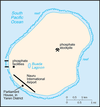
Extraordinary Nauru is a tiny island with a big history and even bigger hospitality. Nauru is located in the deep, blue Pacific Ocean waters north of the Solomon Islands. An uplifted coral formation, Nauru is just 21 kilometres square and lies some 40 kilometres south of the Equator. One of the smallest nations on earth, with a mostly Micronesian population of around 10,000 people, Nauru offers travellers a truly unique Pacific Island visit. Discover excellent deep sea fishing, scuba dive amazing ocean depths, take a tour of the island’s past economic mainstay the phosphate mines or simply experience a holiday in a world far from your own.
Nauru Google Maps
To activate Street View on any city of Nauru, drag above the Zoom feature the yellow little man in the map.
Facts about Nauru
| Administrative divisions: | 14 districts; Aiwo , Anabar , Anetan , Anibare , Baiti , Boe , Buada , Denigomodu , Ewa , Ijuw , Meneng , Nibok , Uaboe , Yaren |
| Area: | total: 21 sq km land: 21 sq km water: 0 sq km Navassa Island |
| Background: | The exact origins of the Nauruans are unclear , since their language does not resemble any other in the Pacific. The island was annexed by Germany in 1888 and its phosphate deposits began to be mined early in the 20th century by a German-British consortium. Nauru was occupied by Australian forces in World War I and subsequently became a League of Nations mandate. After the Second World War - and a brutal occupation by Japan - Nauru became a UN trust territory. It achieved its independence in 1968 and joined the UN in 1999 as the world's smallest independent republic. Navassa Island |
| Flag description: | blue with a narrow , horizontal , yellow stripe across the center and a large white 12-pointed star below the stripe on the hoist side; the star indicates the country's location in relation to the Equator (the yellow stripe) and the 12 points symbolize the 12 original tribes of Nauru Navassa Island |
| Capital: | no official capital; government offices in Yaren District time difference: UTC+12 (17 hours ahead of Washington , DC during Standard Time) |
| Climate: | tropical with a monsoonal pattern; rainy season (November to February) Navassa Island |
| Currency code: | Australian dollar (AUD) |
| Ethnic groups: | Nauruan 58% , other Pacific Islander 26% , Chinese 8% , European 8% |
| Geographic coordinates: | 0 32 S , 166 55 E Navassa Island |
| Geography note: | Nauru is one of the three great phosphate rock islands in the Pacific Ocean - the others are Banaba (Ocean Island) in Kiribati and Makatea in French Polynesia; only 53 km south of Equator Navassa Island |
| Government type: | republic |
| Imports partners: | South Korea 43.8% , Australia 36.2% , US 5.9% , Germany 4.3% (2006) |
| Internet country code: | .nr |
| Land boundaries: | 30 km Navassa Island |
| Neighbouring countries: | 0 km Navassa Island |
| Languages: | Nauruan (official; a distinct Pacific Island language) , English widely understood , spoken , and used for most government and commercial purposes |
| Location: | Oceania , island in the South Pacific Ocean , south of the Marshall Islands Navassa Island |
| Map references: | Oceania Navassa Island |
| National holiday: | Independence Day , 31 January (1968) |
| Nationality: | noun: Nauruan(s) adjective: Nauruan |
| Natural hazards: | periodic droughts Navassa Island |
| Population: | 13 ,770 (July 2008 est.) Navassa Island |
| Religions: | Nauru Congregational 35.4% , Roman Catholic 33.2% , Nauru Independent Church 10.4% , other 14.1% , none 4.5% , unspecified 2.4% (2002 census) |
| Terrain: | sandy beach rises to fertile ring around raised coral reefs with phosphate plateau in center Navassa Island |
| Unemployment rate: | 90% (2004 est.) |
Capital of Republic of Nauru
[PLACE_CAPITAL] (click to view [PLACE_CAPITAL] map)
Places in Nauru
Browse the most comprehensive and up-to-date online directory of administrative regions and Street Views in Nauru. Our listings are organized alphabetically, starting from level 1 regions and progressing through to level 2 and eventually level 3 regions, ensuring you can easily navigate and find specific areas of interest.
Random cities in Nauru
[PLACE_CAPITAL], the capital city of Nauru.Link to Nauru Google Maps page
The map of Nauru has already attracted 2646 views. If you wish to embed our comprehensive Nauru map on your site, we offer an easy solution. This map includes free access to Google Maps, gazetteer search, detailed country and city maps, Street View, and essential facts, all ready to enhance your website. To use it, simply copy and paste the provided HTML code into your webpage's source code. We appreciate every link back to our Maps and Driving Directions. Thank you for your support!
| Text link to: Nauru map and facts page |
This Nauru map is intended solely for informational purposes. No representations or warranties are made concerning its accuracy or reliability. Users assume all risks associated with the use of Google Maps and Google Driving Directions. World Route Planner is not liable for any losses or delays that may occur from using this free Nauru map.